In the coming week, tens of millions of Americans will face the threat of severe weather as a massive storm sweeps across the country, bringing hurricane-force winds, major flooding, blizzard conditions, and the potential for a tornado outbreak.
Meteorologists warn that the storm is set to impact nearly every region, beginning Wednesday as it moves ashore along the Pacific Coast.
California and other western states will see heavy rain and snowfall, with the National Weather Service in Los Angeles cautioning about the risk of rock and mudslides.
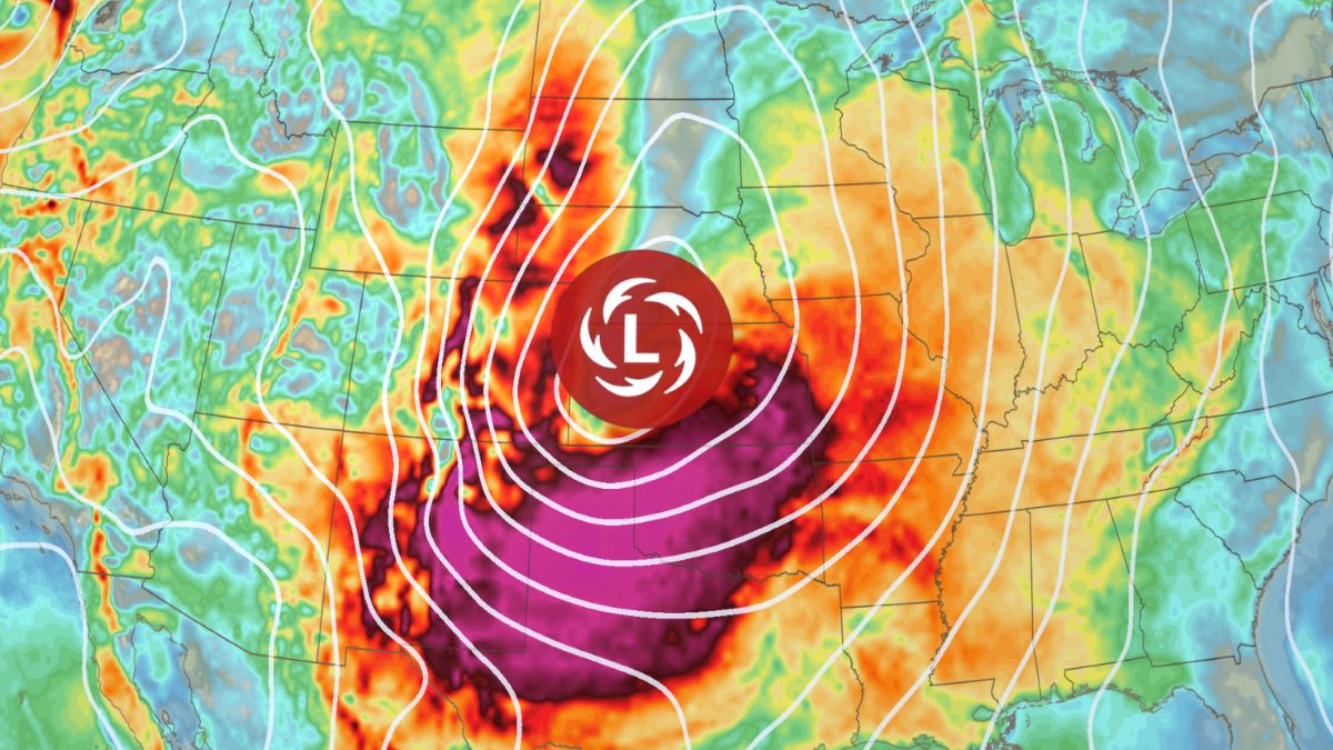
By Friday, the storm will expand across almost the entire central U.S., stretching from the Gulf Coast to the Canadian border. The system is expected to produce whiteout conditions, powerful winds, unusually warm temperatures, wildfires, dust storms, and tornadoes.
“This is going to be a very significant, very strong storm,” he said, noting that the extreme weather is likely to cause power outages and major travel disruptions on roads and at airports.
The forecast comes just days after a similarly vast storm swept across the U.S. last week, dumping snow in the northern Plains while generating tornadoes and wildfires in the South. At least five deaths in Nebraska and Mississippi were linked to that system.
The western United States is preparing for a powerful storm that will bring heavy rain, significant snowfall, and strong winds across multiple regions.
Severe Weather Hits the West Coast
According to the National Weather Service, the storm will make landfall on the West Coast early Wednesday, delivering heavy rainfall to coastal California.
Southern California faces an increased risk of flash flooding and debris flows, particularly in areas that were impacted by January’s wildfires, the weather service warned. San Francisco is also expected to experience substantial rainfall on Wednesday.
As the system moves inland, the Sierra Nevada mountains could receive between 2 to 4 feet of snow, while widespread wind gusts of 40 to 70 mph will sweep across the region.
From Thursday into Friday, snowfall will extend across the Rockies, affecting parts of Nevada, Utah, and Arizona—states that have received less snow than usual this winter.
By the weekend, the storm will intensify as it moves into the Plains, bringing the potential for heavy snow and blizzard conditions, the Weather Prediction Center said.
While the storm will create hazardous travel conditions, it will also provide much-needed precipitation.
“More storms with generous rain and mountain snow are needed prior to the beginning of the dry season, less than a couple of months away,” said AccuWeather senior meteorologist Alex Sosnowski.
Severe Weather in US
Severe Thunderstorms Threaten Nearly 500,000 Square Miles
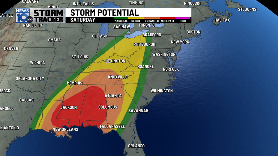
By Friday, severe weather warnings will be widespread, with nearly half a million square miles from Texas to the Dakotas at risk of dangerous thunderstorms, according to AccuWeather.
Meteorologists are concerned that the storm could trigger a tornado outbreak, potentially producing dozens of twisters from the Gulf Coast to the Midwest.
One of the storm’s most significant threats will be widespread damaging winds of 65 to 75 mph, with gusts possibly reaching up to 100 mph.
These extreme winds could result in power outages, flight disruptions, downed trees, and the rapid spread of wildfires, particularly in the drought-stricken Plains and Southwest.
On Saturday, the storm will continue moving east, bringing thunderstorms to Louisiana, Alabama, Tennessee, the Florida Panhandle, and western Georgia.
As the storm encounters the Appalachian Mountains, it may slow down, increasing the risk of flash flooding in the Tennessee Valley.
Southwest Faces Fire Risk and Dust Storms
On the drier side of the system, the Southwest will likely face critical fire weather conditions and dust storms as strong winds move through the region.
The National Weather Service warned that the parched Southwest will receive little to no rainfall but will experience low humidity and high winds, increasing the risk of fast-spreading wildfires.
Areas at particular risk include western and central Texas, southeast Arizona, and southern New Mexico, especially on Friday. Red flag warnings were issued across the region on Tuesday.
In addition to the wildfire threat, dust storms could return to the Southwest. Last week, strong winds created massive dust clouds that disrupted traffic, shut down businesses, and led to air quality alerts in Texas and New Mexico.
East Coast Will Also Be Affected
As the storm moves toward the Atlantic Coast into Sunday, several major cities may be impacted.
Kines noted that severe weather could extend into the Interstate 95 corridor, affecting cities such as Washington, D.C., Philadelphia, New York, and Boston.
“The eastern part of the country will not be left out,” he said, though the exact impacts remain uncertain.
Possible Record-Breaking Temperatures Across Central U.S.
Ahead of the storm, large portions of the country will experience above-average temperatures, with some areas potentially breaking daily records, Kines said.
Chicago, for example, could see temperatures climb into the upper 70s on Friday, approaching the city’s record high for the date. Other cities that may experience record highs include Kansas City, Missouri, and Minneapolis.
Meanwhile, southern Texas could see temperatures soar into triple digits—far above its seasonal average in the lower 80s.